Convergent Vectors Divergent Vectors Continuing Vectors
Divergence in Natural Coordinates
A. Background
While it is easy to visualize how divergence occurs with respect to pressure patterns when there is NO Coriolis effect (air moves at right angles to pressure or height contours towards low values), how does divergence "appear" on charts on which the wind is flowing parallel (or nearly parallel) to contours.
While it is difficult to visualize this, or actually see it on charts, divergence can be conceptualized better if one transforms it into the natural coordinate system. (As before, divergence in natural coordinates takes the form of ∆V/∆s, and has conventional units).
B. Diffluence and Speed Divergence
The concept equation for divergence in natural coordinates is as follows:
Horizontal Divergence = Diffluence + Speed Divergence
(Note: if diffluence is negative, it is called confluence, and if speed divergence is negative it is called speed convergence). The plus sign merely means you have to consider both effects, although the algebraic sign of one or both of the terms can be negative.
Let's consider this using the 500 mb level, since that is near the Level of Non-divergence. The concept equation above should produce a value near zero, therefore, when applied to the 500 mb level.
You have enough experience with charts drawn for the middle and upper troposphere (700 mb to 200 mb) to realize that the height and wind patterns resemble sine waves, with ridges and troughs. Let's examine the trough that was associated with the storminess in Southern California on February 22, 2005.
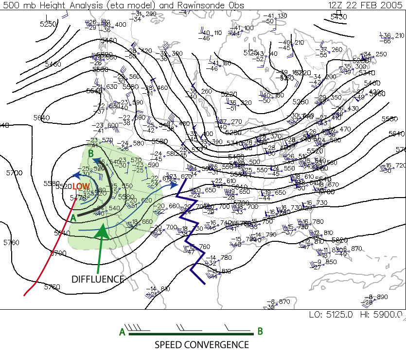
Note that in the green shaded area the wind streamlines are generally splitting apart from trough axis to ridge axis. This is called diffluence and it is very characteristis of trough/ridge systems in the jet stream that diffluence occurs east of troughs and confluence east of ridges.
That would suggest to the eye, at least, that divergence is occuring in the green region. But this is the 500 mb level, the level at which Non-divergence should be occuring.
Note that along each streamline, however, the wind speeds are stronger near the trough axis and weaker near the ridge axis. The inset shows the streamline that stretches from A to B on the chart. You will note that speed convergence is occurring along the streamline (meaning, that the air parcels on the west side of the streamline are "catching up" to the air parcels on the east side.
Thus in the concept equation above, diffluence would have a positive sign, but there would be a negative speed divergence. At the Level of Non-Divergence, these two terms are very nearly equal in opposite, producing non-divergence.
Let's take a look at a chart in the upper troposphere.
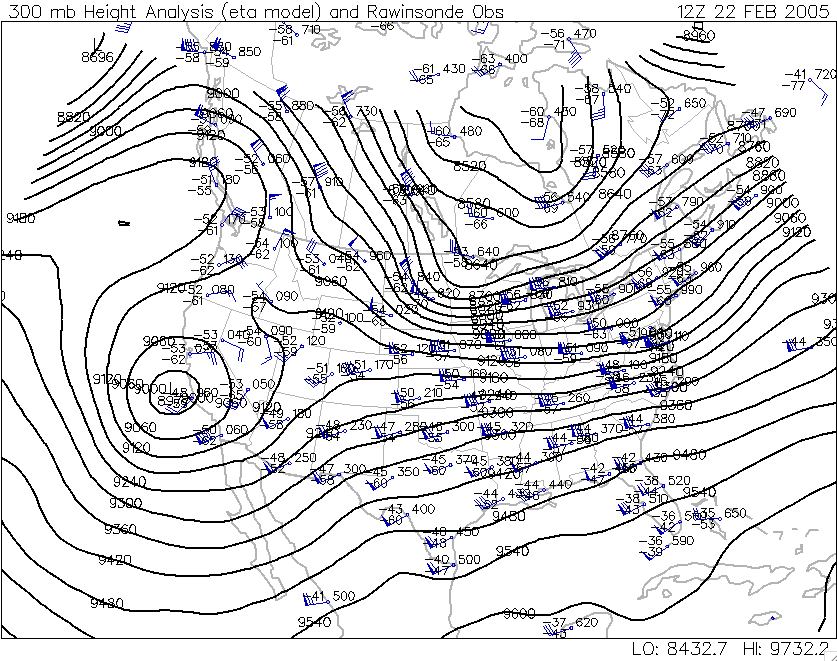
Note first that the chart has a very similar geometry, meaning the troughs and ridges are in basically the same location as they are on the 500 mb chart, as is the jet stream (this occurs in all cases, allowing you to infer positions of jet streams and troughs and ridges in the upper troposphere simply by looking at a 500 mb chart).
Note also that diffluence is occurring in the same region as it is on the 500 mb chart. But, to some extent, so is speed convergence. At this point, we must leave the quasi-quantative discussion aside, because it turns out that in the upper troposphere the two terms generally are not balanced...so that diffluence "wins" out, producing net divergence east of trough axes.
Below is excerpt from following web page: http://www.propilotmag.com/archives/2013/April%2013/A4_Wx%20Brief_p1.html
Although air is in constant movement through all parts of the troposphere, the layer itself can be divided, meteorologically, in half. The lower half is the layer that provides the heat and moisture needed to support convection, while the upper half is the layer that promotes or suppresses the vertical motion of the air from below. The halfway point�around 500 mb or roughly FL180�is known by meteorologists as the level of nondivergence.
The level of nondivergence (LND) is so called because it rests beneath the upper levels of the troposphere, where a great deal of convergence or divergence of air flow takes place. This convergence and divergence is what helps to enhance or suppress the pressure systems moving along the surface.
For example, an area of diverging air in the upper troposphere will lower the air density aloft, encouraging the uplift of lower-level air and enhancing a surface low beneath it.
Conversely, upper troposphere convergence will increase density there, resulting in increased surface pressure. The strength of convergence or divergence aloft can best be captured by evaluating conditions at the LND. One of the most important measures of the potential of the upper levels to support convergence or divergence is vorticity .
500 MB HEIGHT PATTERN AND PRECIPITATION
The 500 mb pattern can also be used to locate where surface storms and precipitation are most likely to be occurring. Surface storms and precipitation are most often found over areas downstream of 500 mb troughs (following the horizontal wind direction from a trough to a ridge). The reason for this is that rising air motion is forced in this part of the flow pattern. Rising motion means that surface air is forced to move upward into the atmosphere. Clouds and precipitation develop where air rises. Thus, we try to use weather maps to pick out areas where air is forced to rise upward, as these are places where precipitation may be occurring. Conversely, sinking air motion is forced over areas downstream of ridges. Clouds do not develop where air is sinking. Underneath these areas fair weather is most likely. By looking at a 500 mb map, you should be able to distinguish where precipitation is most likely and where fair weather is most likely.
The reason that rising motion occurs just downstream of 500 mb troughs is that in this region divergence of air occurs above the 500 mb height level in the upper troposphere, while just downstream of ridges, sinking motion occurs as a result of convergence of air above the 500 mb height level in the upper troposphere. Divergence occurs when horizontal winds cause a net outflow of air from a region (more air leaving a vertical column of air than entering), while convergence occurs when horizontal winds cause a net inflow of air into a region (more air entering a vertical column than leaving it). Take a look at these Notes on dynamical lifting of air to help you to understand what is meant by divergence and convergence, and why divergence above the 500 mb level in the upper troposphere forces air in a vertical column to rise, while convergence above the 500 mb height level in the upper troposphere forces air in a vertical column to sink. You are not expected to understand why upper level divergence and convergence occur downstream of upper level troughs and ridges respectively, just that it does. You should associate upper level divergence, which occurs downstream of 500 mb troughs, with rising air, clouds, and precipitation. Conversely, you should assoicated upper level convergence, which occurs downstream of 500 mb ridges, with sinking air and fair weather (lack of clouds and precipitation). As shown in the Notes on dynamical lifting of air, the relationship between horizontal divergence/convergence of winds just above the ground surface (at low height levels in the lower troposphere) and rising motion is reversed. This will be discussed further in later lectures along with a review of horizontal convergence and divergence. Typically, where air is rising upward, there will be convergence at low altitudes (below the 500 mb height) and divergence at high altitudes (above the 500 mb height). Conversely, where air is sinking downward, there will be divergence at low altitudes (below the 500 mb height) and convergence at high altitudes (above the 500 mb height). These concepts are also shown in the figure below. This is important since clouds and precipitation happen where air is moving upward with generally cloud-free conditions expected where air is moving downward.
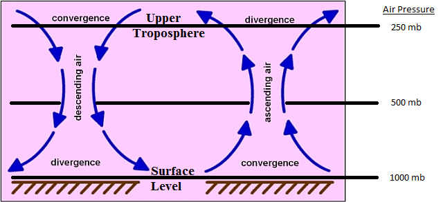 |
Relationship between horizontal covergence and divergence and vertical air motion.
|
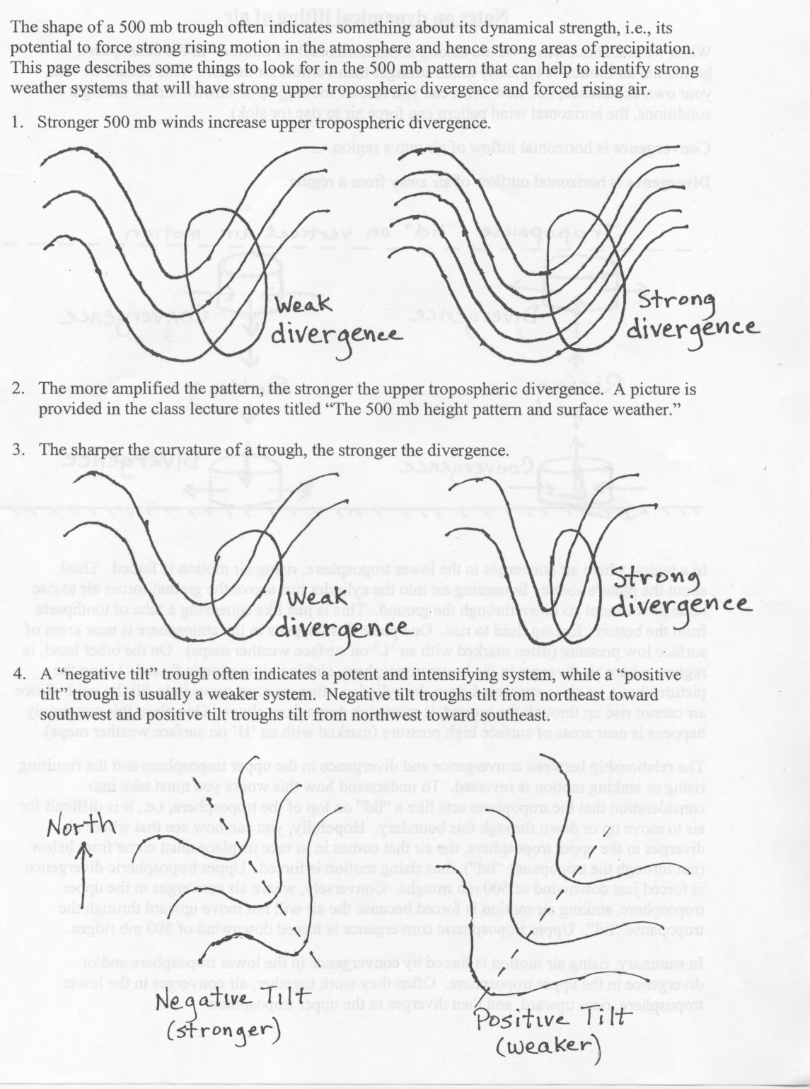
The amount of precipitation that occurs with a winter-type storm depends on two main factors: atmospheric dynamics (how strongly air is forced to rise) and the availability of water vapor. Keep in mind that if the air does not contain sufficient water vapor, then no matter how forcefully it rises, clouds and precipitation will not form. On the other hand, if the air contains a lot of water vapor, then it does not take much lifting before clouds and precipitation will form. The stronger the divergence of air in the upper troposphere, the stronger air is forced to rise. The shape of a 500 mb trough often indicates something about its dynamical strength, i.e., its potential to force strong rising motion in the atmosphere and hence strong areas of precipitation. Below is a list of several things to look for in 500 mb pattern that act to increase divergence and hence rising motion. Link to Hand-drawn pictures for the items in the list.
- Stonger winds increase divergence. Therefore, the more closely spaced the height lines, the stronger the divergence downwind of troughs.
- The more amplified the pattern (amplitude of the ridge/trough pattern), the stronger the divergence downwind of troughs.
- The sharper the curvature of a trough, the stronger the divergence downwind of the trough. This is very important when considering shortwaves (defined below).
- The orientation of the trough axis with repect to a north-south line. Troughs that are oriented along a northwest to southeast line are said to a have a "negative tilt", while troughs oriented along a northeat to southwest axis are said to have a "positive tilt." In general, a negatively tilted trough indicates a stronger weather system.
Source: https://www.weather.gov/source/zhu/ZHU_Training_Page/Miscellaneous/Divergence/divergence.html